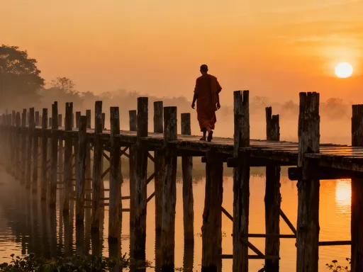
Lost in the Limestone: Secrets Beneath Nuremberg’s Wild Hills
You know what I didn’t expect in Nuremberg? Jaw-dropping limestone cliffs, hidden gorges, and forest-carved ravines that feel like another world. Forget just castles and Christmas markets—this city’s surrounding landscape is shaped by mind-blowing geological forces. I’m talking layers of ancient rock, wind-sculpted stone formations, and trails that lead straight into the Earth’s story. This is raw, wild, and totally underrated. Let me take you where the real adventure begins—beneath the surface. While most visitors come for medieval ramparts and fragrant gingerbread, few realize that within a short journey from the city center lies a realm where nature has spent millions of years carving cathedrals out of stone. The region around Nuremberg, particularly the area known as Fränkische Schweiz (Franconian Switzerland), offers one of Germany’s most dramatic non-alpine landscapes—where rivers slice through limestone, caves yawn beneath forest floors, and climbing routes trace the edges of time itself. This is not just scenic countryside. It’s a living archive of Earth’s history, waiting to be explored.
Unveiling Nuremberg’s Hidden Natural Side
Nuremberg is often celebrated for its pivotal role in European history—the Imperial Castle looming over cobbled streets, the solemn reminders of the Nuremberg Trials, and the world-famous Christkindlesmarkt drawing crowds every winter. Yet beyond the city’s storied walls lies a landscape of surprising wildness. Just 30 to 60 minutes by car or regional train, the rolling hills of northern Bavaria unfold into a terrain sculpted not by human hands, but by the slow, persistent forces of water, wind, and time. This is the heart of Fränkische Schweiz, a protected natural park and one of Germany’s most geologically distinctive regions. Here, the land rises and falls in dramatic folds, where limestone plateaus give way to deep ravines and sudden drops reveal the skeletal structure of the Earth.
The term 'Schweiz'—meaning Switzerland—was coined by 18th-century romantics struck by the area’s rugged beauty, even though the elevation never approaches the Alps. What makes this region exceptional is its karst topography: a landscape formed from soluble bedrock, primarily limestone, that dissolves over millennia to create sinkholes, underground rivers, caves, and towering cliffs. Unlike the volcanic or glacial formations found elsewhere in Europe, the drama here is quiet, patient, and deeply layered. Over 250 million years, the accumulation and erosion of marine sediments have produced a terrain that feels both ancient and alive. Sinkholes, known locally as dolines, dot the countryside like footprints from a forgotten giant, while dry valleys hint at water’s invisible passage beneath the surface.
What surprises most visitors is how accessible this wild beauty remains. Unlike remote wilderness areas requiring technical gear or extensive trekking, Fränkische Schweiz is crisscrossed by well-maintained trails, family-friendly paths, and signposted routes that guide hikers, climbers, and curious explorers into the heart of its geological wonders. Small villages like Tüchersfeld, Pottenstein, and Gößweinstein serve as gateways, offering cozy guesthouses, local eateries serving Franconian specialties, and visitor centers with detailed maps and historical context. This blend of natural spectacle and human hospitality makes the region not just a destination for adventurers, but for anyone seeking a deeper connection with the land.
The Geology Behind the Drama: How Nature Built These Landscapes
To understand the magic of Fränkische Schweiz, one must journey back—far back—to a time when this part of Europe lay beneath a shallow tropical sea. Around 250 million years ago, during the Late Permian and early Triassic periods, the region was part of a vast marine basin where countless marine organisms lived, died, and settled on the seafloor. Their calcium-rich shells and skeletons accumulated over millions of years, compressing into thick layers of limestone. These deposits, now exposed through uplift and erosion, form the backbone of the region’s dramatic scenery.
The transformation from seabed to rugged highlands began with tectonic shifts that lifted the land, followed by relentless weathering. The key player in this ongoing transformation is water—specifically, slightly acidic rainwater. As rainfall absorbs carbon dioxide from the atmosphere and soil, it becomes a weak carbonic acid. This subtle acidity allows water to dissolve limestone over time, a process known as karstification. The result is a landscape riddled with features that seem almost otherworldly: sinkholes where the ground has collapsed inward, underground rivers that vanish and reappear, and springs that bubble up from deep within the rock.
One of the clearest examples of this process can be seen in the Wiesenttal Valley, where the Wiesent River follows a path dictated by subterranean weaknesses in the limestone. Along its course, the river has carved a meandering ribbon through the rock, flanked by steep cliffs and dotted with exposed strata that tell the story of ancient sea levels and sedimentation patterns. Equally revealing is the Erlanger Bergwald, a forested ridge where hikers can observe exposed rock faces showing distinct layering—each band a snapshot of a different geological era. Dolines, some large enough to hold small meadows, are common throughout the region, often forming where underground cavities have collapsed under their own weight.
While the science behind these formations is complex, the experience of witnessing them is profoundly simple. Standing at the edge of a sinkhole or tracing a finger along a ripple-marked stone, one feels a direct connection to forces far older and more powerful than human history. There’s a humbling beauty in knowing that every cliff, cave, and crevice is the product of time measured not in centuries, but in eons.
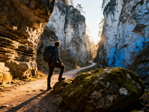
Exploring the Gorges: Walking Through Earth’s Sculptures
If the geology of Fränkische Schweiz is its foundation, then the gorges are its masterpiece. Among the most striking is the Wiesenttal, a valley carved by the meandering Wiesent River as it cuts through layers of limestone, creating narrow passages, moss-draped boulders, and towering rock walls that rise like natural fortresses. Here, the trail often hugs the riverbank, winding between ancient beech trees and fern-covered outcrops. Sunlight filters through the canopy in golden shafts, illuminating patches of emerald moss and lichen-painted stone. The air is cool and carries the constant murmur of flowing water, broken only by the occasional call of a kingfisher or woodpecker.
Another highlight is the Höllental—literally “Hell’s Valley”—a dramatic ravine near the village of Tüchersfeld. As the name suggests, the landscape here feels almost mythical. The path descends into a narrow cleft where the rock walls close in, rising 30 to 40 meters on either side. In some sections, wooden walkways and iron handrails guide visitors through the most treacherous stretches, adding an element of adventure without compromising safety. The contrast between shadow and light is striking: one moment you’re in full sun, the next enveloped in cool darkness, the sound of your footsteps echoing off the stone.
These gorges are not just visually stunning—they offer a multisensory journey. The scent of damp earth and pine, the texture of rough-hewn rock under your palm, the sudden coolness as you enter a shaded crevice—all contribute to an immersive experience that few traditional tourist sites can match. For families, the trails are generally well-marked and manageable, though some sections require sturdy footwear and moderate physical ability. The best times to visit are spring and early autumn, when temperatures are mild, foliage is lush, and the risk of summer crowds or winter ice is minimized.
Safety is important, especially after heavy rains when some paths may become slippery or temporarily flooded. Local authorities maintain the trails diligently, posting clear signage and weather advisories at trailheads. Parents with young children will appreciate the presence of railings and viewing platforms at key points, while more experienced hikers can extend their routes into less-traveled forest paths. Regardless of skill level, the gorges offer a rare chance to walk through a landscape that feels untouched by time, where every turn reveals a new geological wonder.
Climbing the Cliffs: Where Adventure Meets Geology
For those drawn to vertical challenges, the limestone cliffs of Fränkische Schweiz offer some of the most rewarding rock climbing experiences in Central Europe. The area around Pottenstein and Gößweinstein is particularly renowned, attracting climbers from across Germany and beyond. What sets these routes apart is the unique character of the rock itself. The porous, honeycombed texture of the limestone provides a variety of handholds and footholds, making climbs both technically engaging and physically demanding. Unlike the smooth granite of alpine regions, this stone invites tactile exploration—each grip tells a story of erosion and resilience.
There are routes for all levels, from beginner-friendly faces with bolted protection to overhanging crags that test even seasoned climbers. The Tüchersfeld Rocks, with their striking red-tinged limestone towers, are a favorite among enthusiasts. Here, climbers ascend routes with names like 'Rotspitz' and 'Falkenwand,' each offering a different challenge and perspective. At the top, the reward is more than just a sense of accomplishment—it’s a panoramic view of the surrounding forest, the Wiesent River snaking through the valley, and distant villages nestled in the hills.
What makes climbing here especially responsible is the strong culture of conservation. Designated climbing zones ensure that sensitive areas—particularly those used by nesting birds like peregrine falcons and eagle owls—are protected during breeding seasons. Climbers are encouraged to stick to marked routes, avoid disturbing vegetation, and minimize chalk use to preserve the natural appearance of the rock. Local climbing associations work closely with environmental agencies to maintain a balance between recreation and preservation.
Even for non-climbers, watching others scale these ancient walls can be a mesmerizing experience. There’s something deeply symbolic about seeing humans reach upward on stone that has stood for millions of years. Visitors are welcome to observe from safe distances, and guided introductory sessions are available for those curious to try. Whether you’re gripping the rock yourself or standing below in awe, the act of climbing here feels less like sport and more like dialogue—with nature, with history, with the very fabric of the Earth.
Discovering Caves: Windows into the Underground
Beneath the surface of Fränkische Schweiz lies a hidden world—one that few ever see but all can feel in the cool drafts that whisper from rock crevices. The region is home to hundreds of caves, formed over millennia as acidic water dissolved limestone, creating vast underground chambers, narrow tunnels, and subterranean rivers. While many remain unexplored or closed for conservation, several are open to the public, offering a rare glimpse into the planet’s inner workings.
One of the most famous is the Teufelshöhle, or Devil’s Cave, located near Pottenstein. This show cave has been welcoming visitors since the 1920s and remains one of Germany’s most visited natural attractions. Guided tours lead guests through illuminated chambers adorned with stalactites, stalagmites, and flowstone formations that glisten like jewels in the artificial light. The air inside is consistently cool, around 8°C (46°F), providing a refreshing contrast to summer heat. The acoustics are remarkable—speaking softly produces echoes that ripple through the chambers, and some rooms are used for occasional concerts, where music seems to rise from the stone itself.
Another fascinating site is the Nerother Burgstollen, a network of man-extended natural tunnels beneath the ruins of Neu-Isenburg Castle. Though smaller in scale, it offers a more intimate experience, combining geological wonder with historical intrigue. The cave system was expanded during the Middle Ages, likely for storage and shelter, and later used during wartime. Today, it serves as an educational trail, with informative panels explaining both the natural formation and human use of the space.
Exploring these caves is a sensory journey. The sound of dripping water marks time like a slow heartbeat. The smell of damp stone and minerals fills the air. And there’s a profound silence beneath the Earth—one that quiets the mind and sharpens awareness. Conservation is paramount; fragile formations can take thousands of years to grow and are easily damaged by touch. Visitors are asked to stay on designated paths, avoid flash photography, and respect the delicate balance of these ecosystems, which support specialized insects, bats, and microorganisms found nowhere else.
Why These Landscapes Matter Beyond Beauty
The value of Fränkische Schweiz extends far beyond its visual appeal. This region is an ecological treasure, supporting a rich diversity of plant and animal life adapted to its unique conditions. Rare orchids bloom in sunlit meadows atop limestone plateaus, while ferns and mosses thrive in the damp, shaded gorges. The cliffs provide nesting sites for protected bird species, and the caves serve as vital hibernation grounds for several bat populations, including the greater horseshoe bat and the Bechstein’s bat—both of which are declining in other parts of Europe.
But the significance of this landscape is not only ecological—it is also cultural. For thousands of years, humans have interacted with this terrain. Prehistoric peoples sought shelter in caves, leaving behind tools and remnants of early life. Medieval communities built castles on rocky outcrops for defense, taking advantage of natural fortifications. Even today, local traditions reflect a deep connection to the land: from stone quarrying techniques passed down through generations to folk tales that speak of spirits in the ravines and treasures hidden beneath the cliffs.
Recognizing this dual importance, regional authorities and environmental groups have implemented strong preservation measures. Parts of Fränkische Schweiz are designated as nature parks and protected landscapes, with strict regulations on development, quarrying, and tourism impact. Volunteer organizations conduct regular clean-ups, monitor wildlife, and educate the public about sustainable practices. These efforts ensure that the region remains not just a destination, but a legacy—one that can be passed on to future generations.
Moreover, the area serves as a living laboratory for geologists, biologists, and climate scientists. By studying rock layers, cave deposits, and ecosystem responses, researchers gain insights into past climate changes and biodiversity patterns. This knowledge is increasingly vital in an era of environmental uncertainty. In this way, the hills around Nuremberg are not just a place to visit—they are a resource for understanding our planet’s past and shaping its future.
Planning Your Own Geological Adventure
Ready to explore? The good news is that experiencing the natural wonders of Fränkische Schweiz is easier than many assume. From Nuremberg’s central train station, regional trains run regularly to towns like Forchheim, Ebermannstadt, and Baiersdorf—the gateways to the region. The journey takes less than an hour, making it ideal for day trips or weekend getaways. For those without a car, local bus services and hiking shuttle routes connect major trailheads, ensuring that even independent travelers can access the most scenic spots.
Start your adventure at one of the official visitor centers, such as the Nationaler Geopark Bayerns Nordgastein in Pottenstein or the Informationsstelle Fränkische Schweiz in Ebermannstadt. These hubs offer detailed trail maps, geological brochures, and advice on current conditions. Many provide interactive exhibits suitable for children, making them excellent starting points for families. Pick up the Fränkische Schweiz hiking map (available in English), which outlines over 1,000 kilometers of marked trails, color-coded by difficulty.
A recommended itinerary begins in Tüchersfeld, where you can hike the Felsenpfad (Rock Path) through the gorge and up to the castle ruins. From there, follow signs to the Wiesenttal Valley and continue along the river toward Gößweinstein, where you can visit the basilica and enjoy a meal at a traditional inn. On day two, explore the Teufelshöhle and take a shorter climb on the beginner routes near Pottenstein. Allow time to simply sit and observe—notice how light changes on the rock face at different times of day, or how water traces its path through fissures.
When packing, bring sturdy hiking shoes, layers for changing temperatures, water, and a small field guide if you’re interested in plants or geology. Spring and autumn offer the most comfortable conditions, though summer brings lush greenery and winter can provide a serene, snow-dusted landscape for the well-prepared. Above all, embrace the philosophy of slow travel: pause often, touch the stone, listen to the silence, and let the landscape reveal itself at its own pace.
In the end, Nuremberg is more than a city of history. It is a threshold—a place where the past is not only written in manuscripts and monuments, but etched into the very rock beneath our feet. The limestone cliffs, hidden gorges, and whispering caves of Fränkische Schweiz invite us to look deeper, to step off the beaten path, and to discover a different kind of heritage—one shaped by time, water, and the quiet power of nature. This is not just a journey through space, but through epochs. And for those willing to listen, the Earth still has stories to tell.